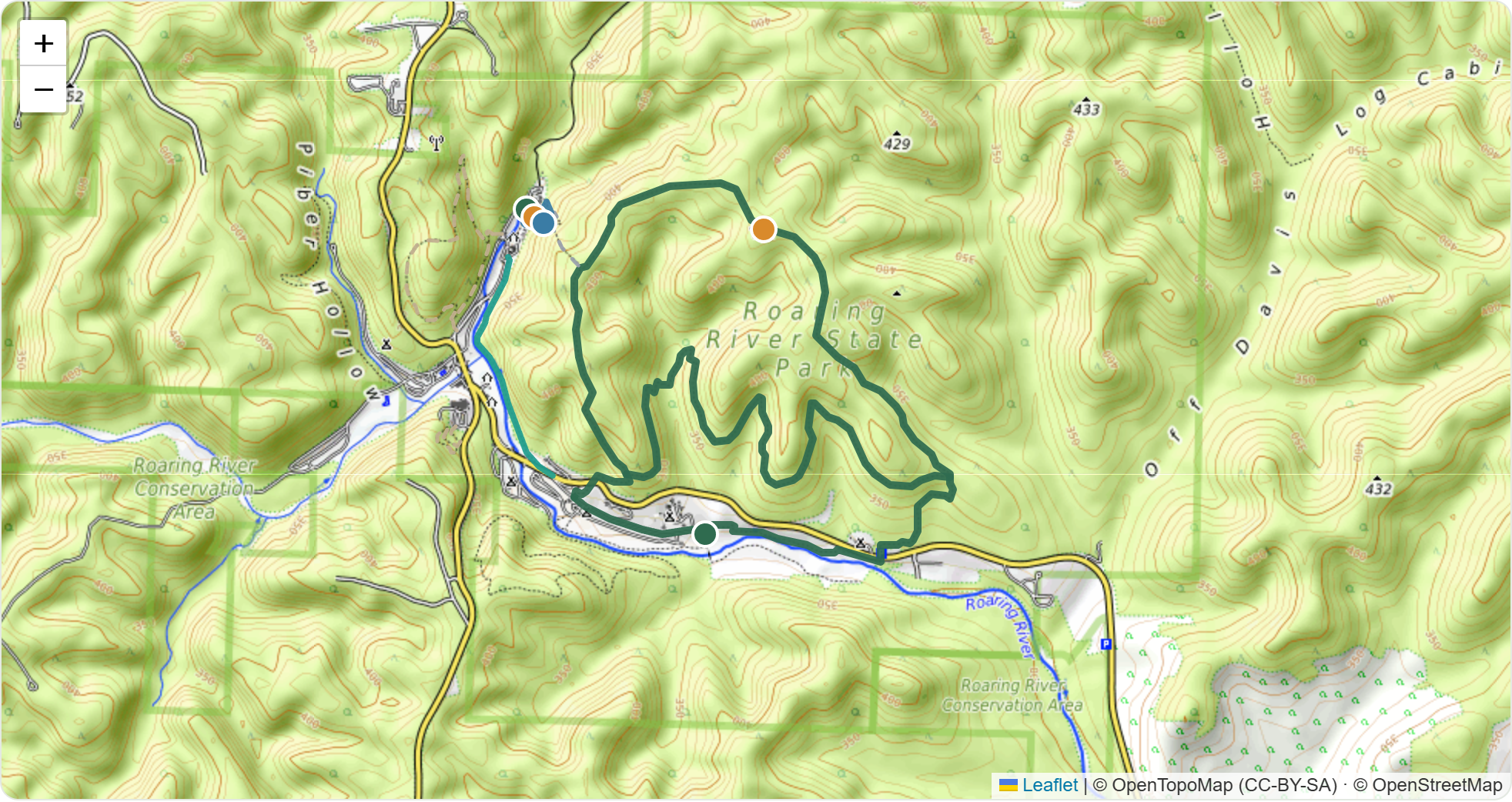
Roaring River State Park Β· Missouri Β· Solo Day-Hike

Fast-Hiker Reset β€” Hike Day

Kids to camp at 2:00, wheels toward the trail by 3:15. Every time below is re-cut for a fast pace so you bank the hatchery view and the full Fire Tower loop with real daylight to spare.

⚑ Fast-hiker pace β˜€οΈ Sunset ~8:30 PM Β· usable light to ~9:00 πŸ“ Bentonville β†’ Kanakuk K-7 β†’ Roaring River
πŸ’‘
Reading of the plan: drop kids at Kanakuk K-7 at 2:00 PM, then depart camp toward the park by 3:15 PM (a 75-min settle/lunch window). If "leave by 3:15" meant leaving the hotel instead, tell me and I'll slide everything ~45 min earlier β€” you'd have even more buffer.
Depart Camp By
3:15 PM
Hard deadline
Park Arrival
~4:00 PM
Deer Leap trailhead
Hike Finish
~7:10 PM
Fire Tower loop done
Daylight Buffer
~1h 20m
before sunset
Foot Distance
7.6 mi
~2h 50m moving

Daylight vs. the clock

Everything finishes well inside the light window.
Deer Leap River Trail Fire Tower Reposition / drive Sunset ~8:30 PM

The re-cut timeline

Fast-pace estimates in the green pills.
2:00
PM
Drop kids β€” Kanakuk K-7
Check-in & settle. ~75-min window before you roll out.
3:15
PM
Depart camp β†’ Roaring River HARD DEADLINE
Leg 2 drive: ~30 mi via Eagle Rock β†’ Cassville β†’ Hwy 112 S. ~40–45 min
~4:00
PM
Arrive park Β· Deer Leap Trail
Park at the spring / CCC Lodge area. Steep stone steps to the overlook above the spring pool & trout hatchery β€” your best close-up of both. 0.4 mi Β· ~20 min fast
~4:30
PM
River Trail OPTIONAL
Flat riverside stretch from the lodge toward Campground 3 β€” a shaded breather on the water before the climb. 1.5 mi Β· ~30 min fast
~5:10
PM
Fire Tower Trail β€” the main event
Reposition to the Nature Center trailhead (Parking 2), then the loop: glades, hardwoods, and the 1930s CCC lookout tower with the park's best view. Follow the yellow & brown arrows counter-clockwise β€” climb to the tower first, descend the back half. Connectors branch off mid-loop. 3.5-mi loop Β· ~2 hrs fast
~7:10
PM
Finish Β· sunset ~8:30 PM
Comfortable daylight buffer. Even at a slower 2.5-hr Fire Tower pace you're down by ~7:40 β€” still ahead of dark.

Trails, at a glance

Times shown at your fast pace.
Deer Leap
Hatchery & spring overlook
0.4
miles
~20m
fast
Steep
steps
Short, sharp climb on wooden/stone steps to a platform right over the spring pool and hatchery. You'll spot the old mid-1800s gristmill waterwheel axle in the spring. Steps can be slick if damp.
Best close-up water view
River Trail
Optional riverside breather
1.5
miles
~30m
fast
Flat
easy
Runs alongside Roaring River from the lodge down toward Campground 3. Flat, shaded, water views the whole way. Easy to add given your fast pace β€” or drop it if you'd rather bank buffer.
Add-on when time allows
Fire Tower
Distance & the big view
3.5
mi loop
~2h
fast
~600'
gain
The park's signature hike β€” glades, hardwood forest, rocky/dolomite sections, and the 1930s CCC lookout tower up top. Blazed with yellow & brown arrows; walk it counter-clockwise from the Nature Center. Official map calls it a 3.5-mi loop β€” GPS apps log 4.4–5.7 depending on start, so the timeline uses the long end to stay safe.
Signature hike Β· best overview

Driving legs

Rural Ozark two-lanes β€” run turn-by-turn live so you don't get a stale backroad.
Leg 1 Β· Aloft β†’ Kanakuk K-7
~50 mi Β· 65–75 min
East out of Rogers toward Beaver Lake / Eureka Springs, then north into Missouri toward Lampe. Leave the hotel with a buffer to hit the 2:00 PM drop-off.
↳ Open Leg 1 in Google Maps
Leg 2 Β· Kanakuk K-7 β†’ Roaring River
~30 mi Β· 40–45 min
West/southwest through Eagle Rock toward Cassville, then south on Hwy 112 to the park entrance. This is the leg that must fire by 3:15 PM.
↳ Open Leg 2 in Google Maps
Aloft Bentonville start Leg 1 Β· ~50 mi Β· 65–75 min Kanakuk K-7 drop 2:00 Β· leave 3:15 Leg 2 Β· ~30 mi Β· 40–45 min Roaring River arrive ~4:00 PM

Trail maps & parking

Schematic β€” orient by these, print the official topo too (links below).
Your one reposition move: park once at the Spring / Hatchery lot for Deer Leap + River Trail, then make a short ~1–2 min drive north up Hwy F to the Nature Center lot for the Fire Tower loop. That's the only time you move the car inside the park.
N Hwy F Β· Fard Rd Roaring River Fire Tower 3.5-mi loop follow yellow/brown arrows β–² CCC Fire Tower White Connector Nature Center P 2 Β· Fire Tower TH P Wild Area lot alt Fire Tower Spring pool hatchery CCC Lodge Deer Leap overlook P 1 Β· Spring / Hatchery lot Deer Leap + River start Β· park here first River Trail 0.7 mi ! cross Hwy F β€” caution Campground 3 ↑ Hwy F north to Cassville / park entrance
Schematic orientation map β€” not to scale. Trails color-coded: green = Fire Tower, blue = Deer Leap / River, gold = overlook + loop direction. Gray dashed = connectors.
1
Spring / Hatchery lot
Park here first Β· Deer Leap + River Trail
By the spring pool, hatchery raceways, and CCC Lodge. Walk the sidewalk to the spring for Deer Leap's steps; River Trail starts from the lodge. Level, accessible spaces.
↳ Google Maps pin
2
Ozark Chinquapin Nature Center lot
Reposition here Β· Fire Tower main TH
Short drive north on Hwy F from the spring. Main Fire Tower trailhead is right off the lot on Hwy F. Nature Center open until 5 PM β€” grab a paper trail map if you beat closing.
↳ Google Maps pin
3
Wild Area lot (Hwy F)
Backup Fire Tower TH
Second Fire Tower access, a bit up Hwy F. Use if the Nature Center lot is full β€” puts you on the loop's east side. Coords β‰ˆ 36.5777, βˆ’93.8232.
↳ Google Maps pin
4
Campground 3 lot
River Trail far end
Only needed if you want to start River Trail from the downstream end instead of the lodge. Also an AllTrails-listed Fire Tower start.
↳ Google Maps pin

Which way to walk each trail

Direction matters most on the Fire Tower loop.

Fire Tower loop β€” walk it counter-clockwise

Follow the park's yellow & brown arrows from the Nature Center trailhead. They run the loop counter-clockwise, which front-loads the sustained climb so you top out at the CCC tower near the midpoint (~1.5 mi in) while your legs are fresh β€” then the back half is a rolling descent home.

If a posted arrow ever disagrees with this, trust the arrow β€” they're maintained on the ground. Stay on the arrowed loop; unmarked connectors branch off mid-trail and are the easy way to add accidental miles.

β–² CCC Fire Tower Β· midpoint START Β· Nature Center TH CLIMB (fresh legs) DESCENT (back half) connectors (Wild Area lot Β· White Connector) branch off β€” stay on the arrows
Fire Tower Β· 3.5-mi loop, yellow & brown arrows, ~1.5–2 h fast.
Deer Leap Β· 0.4 mi out-and-back spring + hatchery steep steps overlook River Trail Β· 0.7 mi each way, flat CCC Lodge Campground 3 ! cross Hwy F Out-and-back either way β€” follows the river the whole flat stretch.
Deer Leap: steps up to the overlook, turn around. River Trail: flat riverside, one Hwy F crossing.

Parking, payment & in-park notes

πŸ…ΏοΈ Parking & payment

Park entrance feeFREE
Trailhead parking (all lots)FREE
Hiking permitNone
MO fishing licenseOnly if you fish
Nature Center hoursOpen until 5 PM

Missouri state parks are free β€” no day-use pass. Grab a paper trail map at the Nature Center if it's still open when you arrive; the loud pyrotechnic vulture deterrent near Campground 3 only runs ~8–10 AM, so it won't affect your afternoon.

🧭 On-trail instructions

  • Trails are color-blazed and well-signed β€” screenshot the map before you drop signal in the valley.
  • On Fire Tower, stick to the main loop markers β€” several connector trails branch off mid-loop and are easy to take by accident.
  • Fire Tower has real gain (~679 ft) and rocky/rugged sections β€” solid footwear earns its keep here.
  • Deer Leap has stone steps + a boardwalk near the spring β€” slick when damp.
  • Given the compressed window, pack a headlamp anyway β€” cheap insurance if the tower loop runs long.

Solo + July pack / safety list

Taps save on this device.